Sunday, December 20, 2009

winter alpine dam loop


a little freezing cold alpine dam loop. been doing a lot of headlands for training lately, but i figured if i posted them every time i'd have to rename the site headlands world. these winter days are too short i tell you!

Saturday, December 5, 2009

headlands+bonus bobcat level


Created by My Tracks on Android.
Total Distance: 47.43 km (29.5 mi)
Total Time: 2:54:03
Moving Time: 2:20:52
Average Speed: 16.42 km/h (10.2 mi/h)
Average Moving Speed: 20.20 km/h (12.6 mi/h)
Max Speed: 54.00 km/h (33.6 mi/h)
Min Elevation: -35 m (-114 ft)
Max Elevation: 245 m (803 ft)
Elevation Gain: 945 m (3102 ft)
Max Grade: 13 %
Min Grade: -14 %
Recorded: Sat Dec 05 12:46:58 PDT 2009

kml file
gpx file
durring a headlands loop i decided to check out a trail that i noticed the other day from looking at google earth. there it was, hiding behind a building on the way to rodeo beach. turned out to be an equestrian road called bobcat trail, and i was finally able to climb some of the marin hills inbetween headlands and mount tamalpias! lots and lots of horses today.


Friday, November 27, 2009

mount diablo loop


this ride started at the pleasant hill bart station. most rides start from home, but as of now there's no way to bike across the bay bridge! unfortunately pat had some trouble with a broken spoke, but we got it all worked out. we climbed up to the summit of mount diablo (iron horse trail - contra costa canal - northgate road) and then descended southgate road to danville, and back to the iron horse trail where it rained all the way back to the bart station. awesome paved paths out there in the east bay! southgate road was an awesome way to bail-down diablo. we even saw some coyotes in rock city on the way down!

Wednesday, November 25, 2009

san bruno mountain


Created by My Tracks on Android.
Total Distance: 45.27 km (28.1 mi)
Total Time: 2:29:52
Moving Time: 2:03:38
Average Speed: 18.15 km/h (11.3 mi/h)
Average Moving Speed: 21.97 km/h (13.7 mi/h)
Max Speed: 61.20 km/h (38.0 mi/h)
Min Elevation: -22 m (-73 ft)
Max Elevation: 361 m (1183 ft)
Elevation Gain: 964 m (3162 ft)
Max Grade: 17 %
Min Grade: -23 %
Recorded: Wed Nov 25 11:16:42 PDT 2009

finally did san bruno mountain for the second time. the first time was in june, and i was riding the fuji from performance (quite terrible).. it was a nice little climb, however since most of the ride is through the city i'd probably use the tank instead of the goat next time. too many stop lights.


Tuesday, November 24, 2009

marin headlands


Created by My Tracks on Android.
Total Distance: 30.00 km (18.6 mi)
Total Time: 3:06:50
Moving Time: 1:21:16
Average Speed: 9.67 km/h (6.0 mi/h)
Average Moving Speed: 22.15 km/h (13.8 mi/h)
Max Speed: 61.20 km/h (38.0 mi/h)
Min Elevation: -14 m (-45 ft)
Max Elevation: 219 m (718 ft)
Elevation Gain: 802 m (2630 ft)
Max Grade: 41 %
Min Grade: -27 %
Recorded: Tue Nov 24 11:54:53 PDT 2009


Saturday, November 21, 2009

cow palace/headlands


Created by My Tracks on Android.
Total Distance: 63.56 km (39.5 mi)
Total Time: 2:37:01
Moving Time: 1:30:15
Average Speed: 11.37 km/h (7.1 mi/h)
Average Moving Speed: 19.77 km/h (12.3 mi/h)
Max Speed: 60.30 km/h (37.5 mi/h)
Min Elevation: -18 m (-58 ft)
Max Elevation: 250 m (820 ft)
Elevation Gain: 895 m (2938 ft)
Max Grade: 30 %
Min Grade: -21 %
Recorded: Sat Nov 21 15:25:28 PDT 2009

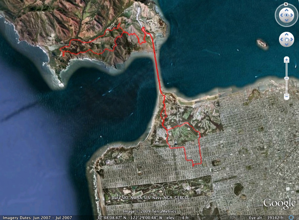
i went to the bike expo down at cow palace on the border of daly city and sf.. i usually don't put city (tank) rides on here, but i thought the expo was pretty cool, so what the hell eh? rode down to the palace and while looking for the entrance somehow i accidentally snuck in. first i ended up "backstage" where all the bmx'ers were "taking off" so i had a nice vantage point for some videos like this:


these guys were AWESOME!
   then i tried to get inside, accidentally placing me on the starting line of the cyclo-cross race..  i followed the riders and veered off into the building.. never found the front entrance, but suddenly i was inside.. cool!


then after a quick trip through the super-ghetto i ran inside (my house), swapped bikes, met up with pat in at the flatlands (ggp @ 6th and fulton) and we rode headlands during the sunset.

Thursday, November 19, 2009

old la honda


Created by My Tracks on Android.
Total Distance: 155.99 km (97 mi)
Total Time: 7:48:23
Moving Time: 6:24:35
Average Speed: 19.30 km/h (12.0 mi/h)
Average Moving Speed: 23.44 km/h (14.6 mi/h)
Max Speed: 65.70 km/h (40.8 mi/h)
Min Elevation: -27 m (-89 ft)
Max Elevation: 649 m (2128 ft)
Elevation Gain: 3130 m (10268 ft)
Max Grade: 58 %
Min Grade: -45 %
Recorded: Thu Nov 19 09:15:49 PDT 2009

this was the first ride where i climbed more than 10,000 feet in a day!
time to explore a little bit more of the santa cruz!

took skyline blvd (gnar gnar suburbia for about 8 miles) over to the san andreas bike path, then cut over to cañada rd and then on to mountain home rd.. after looking around for a bit i found old la honda road (a standard test) and climbed up to the top in 23 minutes. i bailed down to la honda and bounced over to san gregorio on highway 84. climbed up to highway 1 (cabrillo highway) and bailed down to tunitas creek road (a tour of california climb).. climbed up to skyline and BAILED down king's mountain road to woodside... that's when the sun started to go down (glad to be out of the mountains) and so i followed cañada/skyline/san andreas valley path back over to san bruno ave where i bailed-down to the bart station (the sun had set by this time, and those long fast suburban highways are not very cool in the daylight.. can't even imagine in the dark).. took the bart to mission and 16th and rode home from there!